WELCOME TO THE LITTLE RED DOT!
Welcome to a guide for the best photography places in Singapore. While Singapore may be a “little red dot”, a little exploration on the island state will surprise you with its multi-culture and many secret scenic photography spots. This is a compilation of the many locations in Singapore that I have been to over the past years and not just the “tourist” photography spots.
The main purpose of this post is to help people take more photos of the “daily places” in Singapore, other than the Marina Bay Sands and Merlion Park. To anyone visiting Singapore – There is so much more than just the touristy places, it’s time to go on a small adventure in this urban jungle!
ⓘ There are too many photos in this guide and in order to speed up the loading, I have set them to load only as you scroll down. Please do give the photos a few seconds to load, they are not missing and you can click on the photos to enlarge it.
2020 COVID-19 UPDATES
- Light shows in Singapore will be suspended until further notice.
- Major festivals will either be “scaled down” or canceled totally.
- Recreational locations will be closed or limited.
With that, ignore all the “events” section below… Shall update as news come up.
TABLE OF CONTENTS
 Section A Section AHeartlands |
 Section B Section BCity Area |
 Section C Section CParks & Reservoirs |
 Section D Section DEven More Places |
 Section E Section EEvents |
 Closing ClosingPersonal Picks |
THE HEARTLANDS
The town, the neighborhood. The heartlands are where most Singaporean live, and they may appear to be boring places to visit at first. But take a walk down the street, or take the lift up to the top floor of some high rising blocks, and you will be amazed by the bird’s eye view (plus it’s free).
ANG MO KIO
Ang Mo Kio in Hokkien (a Chinese dialect) literally translates to “Bridge of the Caucasian”. Just how did Ang Mo Kio get such a cheesy name? Because a Caucasian once lived here and built a bridge in this town. The Chinese people then started to refer to the bridge as “Ang Mo Kio” with their genius naming sense… That name just got stuck for decades, but sadly today, the bridge is long gone.
1) Sunset from Block 310A

👣 Take bus 133 from AMK hub, it’s just a couple of stops. You can also walk for 10 minutes alternatively, which is not really *that* far. At block 310A, take the lift up to the highest floor (or anywhere you think is high enough), open the door to the common staircase (fire exit). You will be greeted by a bird’s eye view of the town. [MAP]
💓 This is a public housing estate, please do not disturb the residents – Or you might face the wrath of Asian moms. This spot is facing the west and good for sunsets.
2) Sunset from Block 455A
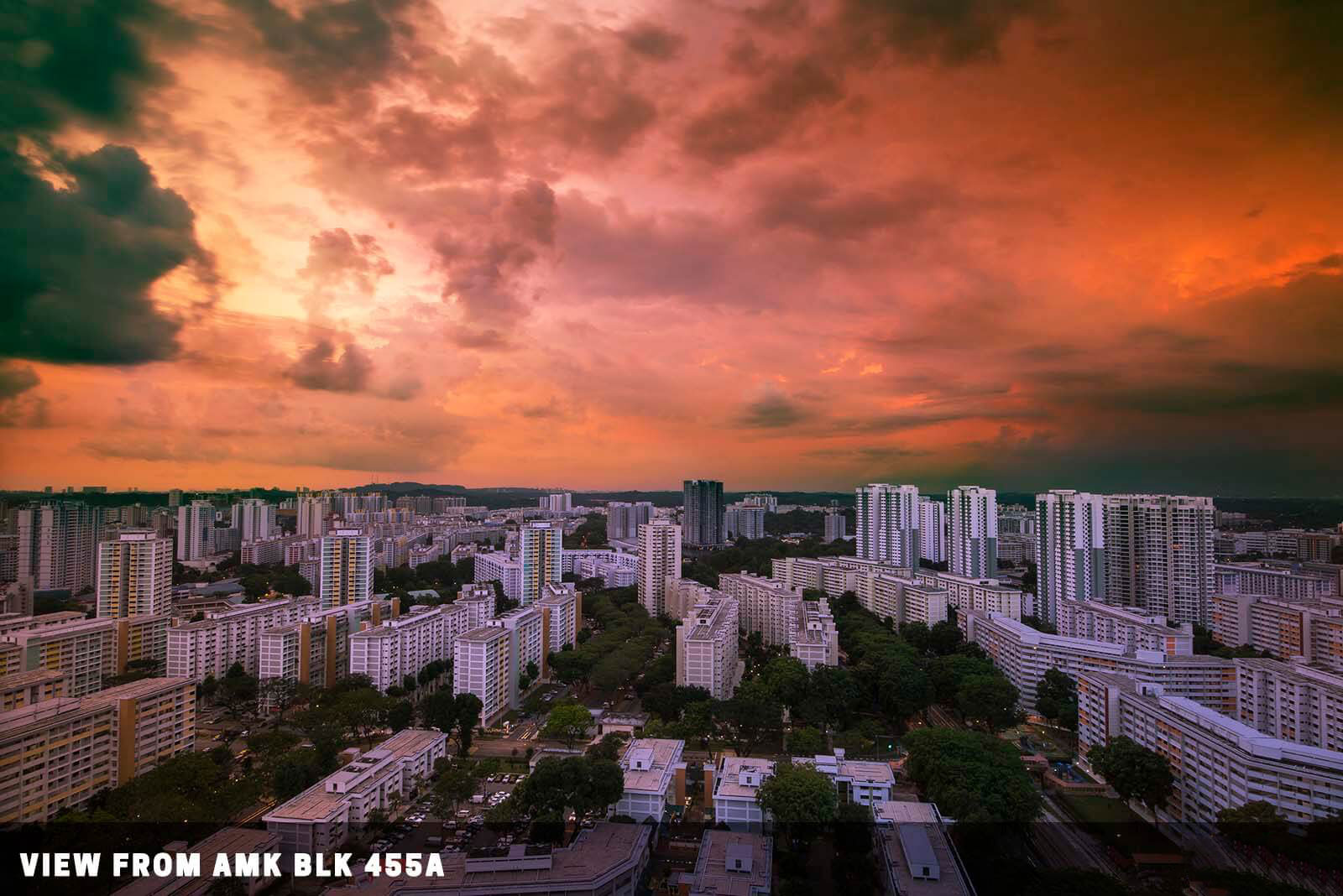
👣 Take bus 25, 55, 73, 74, 76, 132, 165, or 268 from the bus stop right beside the MRT station. Just 3 stops or you can walk for 15 minutes. This place has the same layout as most new HDB flats – Take the lift up to the top floor, open the door to the common staircase, and you will be greeted by a panoramic view of the town. [MAP]
💓 Public housing estate, please do not disturb the residents. West facing and good for sunsets.
3) Panorama of Bishan Park
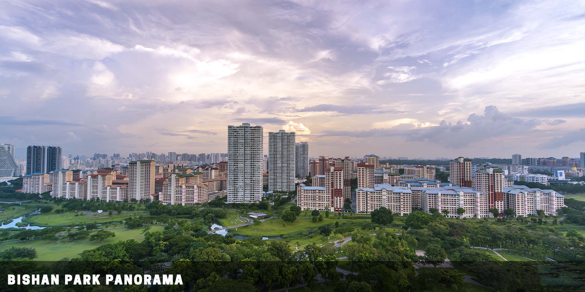
👣 Take bus 262 from AMK hub, alight at block 315B. Take the lift up the block (to a high enough floor), a nice panorama of Bishan Park awaits along the common corridor. [MAP]
💓 This is a public housing estate, do not disturb the residents. This vantage point is south-facing.
TOA PAYOH
Toa Payoh is one of the older mature estates in Singapore, and in Hokkien, it translates to “Big Swamp”. This town used to be nothing but a swamp, and thus the name of Toa Payoh. Yep, our ancestors have a good and straightforward naming sense.
4) Light trails from Block 195

👣 Take bus 235 or 238 from the interchange, stop at blk 27 and take a short walk to block 195. [MAP]
💓 This block is right beside the busy highway. Come during the night, and there are plenty of chances to catch light trails. Just take the lift up, and find your best spot. Public housing estate, do not disturb the residents.
5) The dragon playground

👣 Take a short 5 mins walk from the train station. [MAP]
💓 A walk down memory lane. One of the few remaining dragon playgrounds in Singapore. This may not be interesting for tourists, but it is something of nostalgia to the locals… Go get a photo of it before it’s gone.
6) Toa Payoh 5 fingers highrise from blk 190
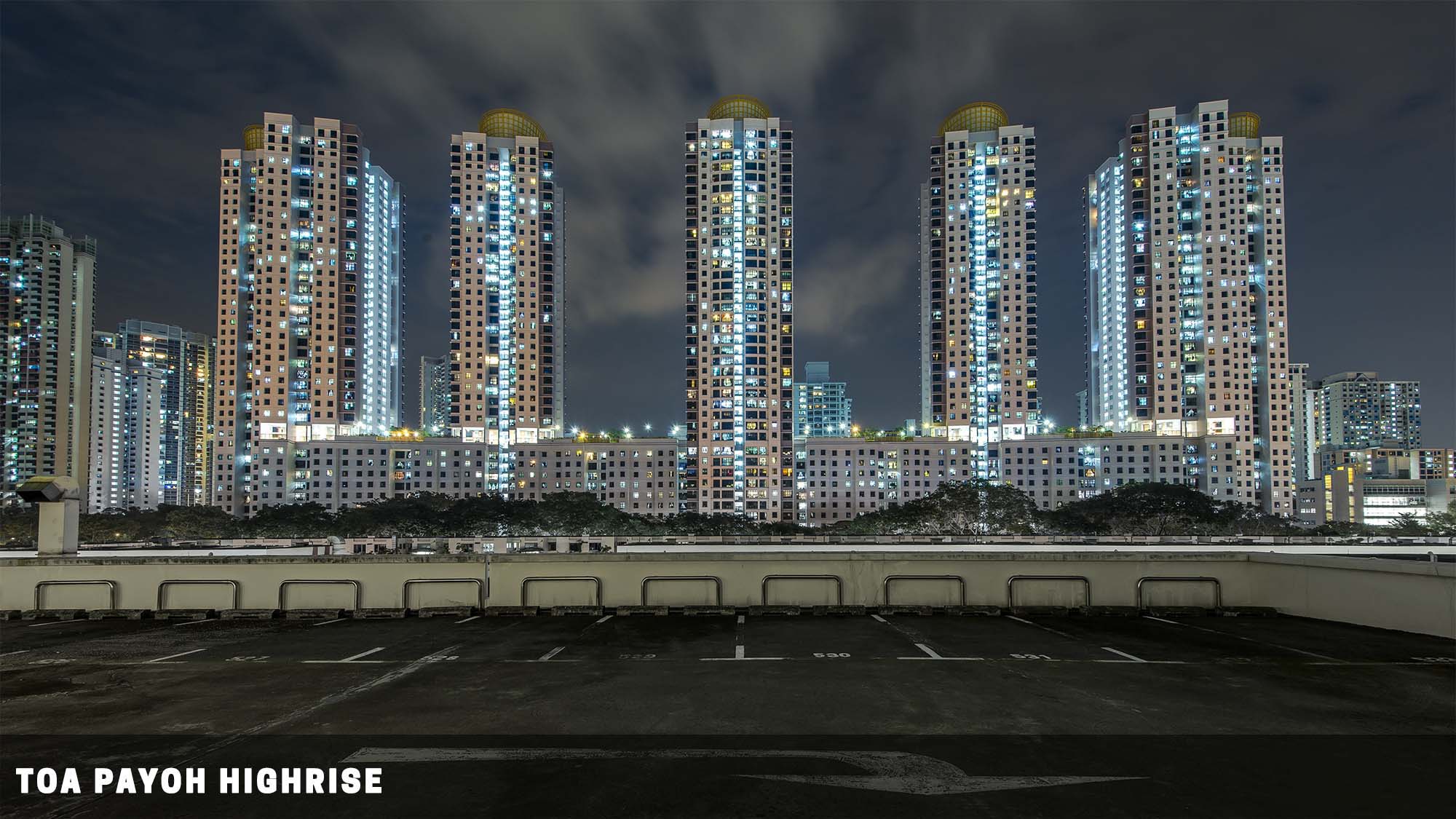
👣 Take a short 5 mins walk from the train station, up the top floor of the car park in blk 190. [MAP]
💓 The fabled 5 fingers mountain that pinned down the monkey god. Now in the modern form of a housing estate. There’s literally no one parking at this carpark… But still, do be on the lookout for incoming vehicles.
QUEENSTOWN
Queenstown is another one of the mature estates in Singapore, and when you get “queen” in the name, it has to be the British. This town is named after Queen Elizabeth II’s coronation in 1952.
7) Skyville@Dawson
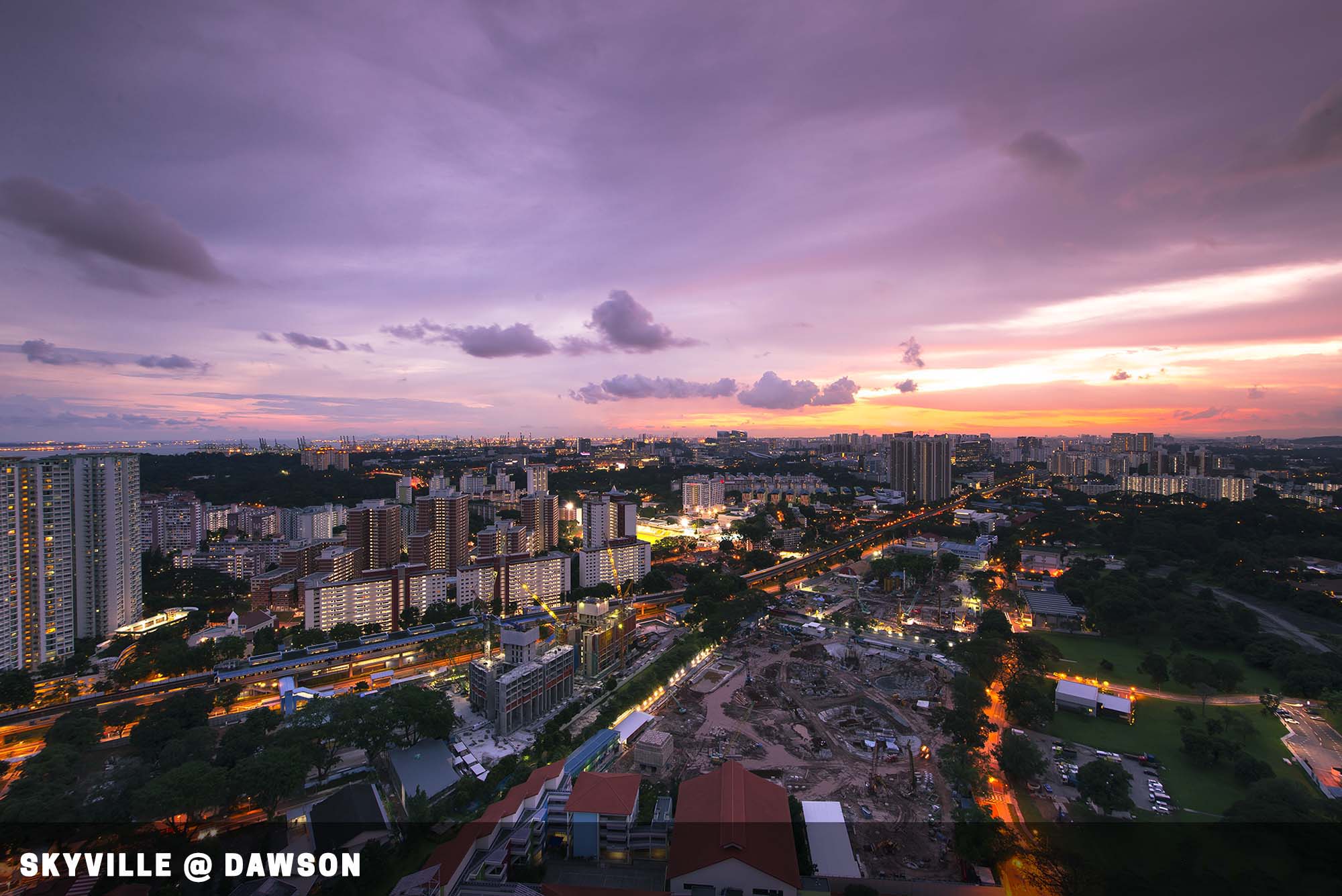
👣 Take a short 10 mins walk from the train station. [MAP]
💓 Panoramic views of Singapore from the sky gardens. The block looks like some sort of private condo, but it’s public housing. Just take the lift up to the sky gardens. I am not sure if greedy folks will start charging “entry fees” to the sky gardens in the future. So go there fast while it’s still free.
CITY AREA
Down in the southern part of Singapore lies the heart of the city. This is where all the bustling financial districts and centers are at, alongside some of the earliest settlements in Singapore – You will find an interesting cross of the past, present, and future all in the city area.
TANJONG RHU AREA
This area used to be a dirty river, docks, and full of industrial warehouses. After the government decided to do the “challenge accepted” task to this area, it transformed into a high-class residential zone.
8) Tanjung Rhu Suspension Bridge
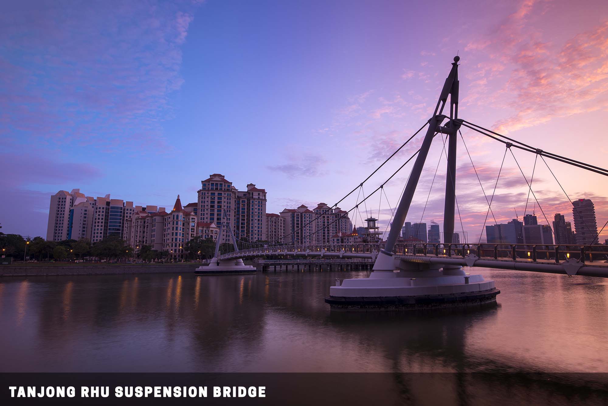
👣 Take a short 5 mins walk from the Stadium train station. [MAP]
💓 Singapore’s first suspension bridge. Great against sunset or twilight. Quite a lot of joggers, cyclists, and e-scooters in the area. Do keep an eye open… Because some of these cyclists don’t.
9) Former Watchtower
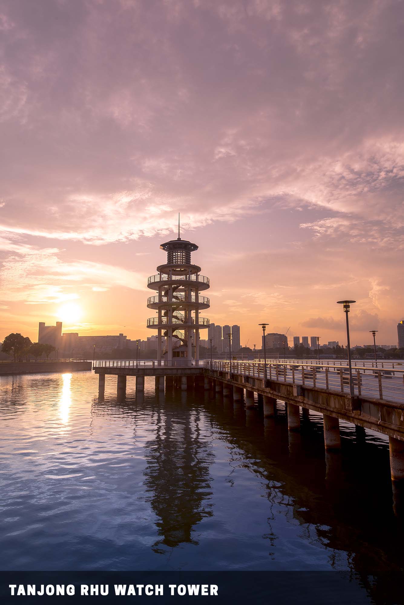
👣 Right beside the Tanjung Rhu suspension bridge. [MAP]
💓 A watchtower that now stands silent. Another great place to chill against the sunset. Not sure if the tower is open to the general public… The authorities here can be quite random on this.
10) Costa Rhu
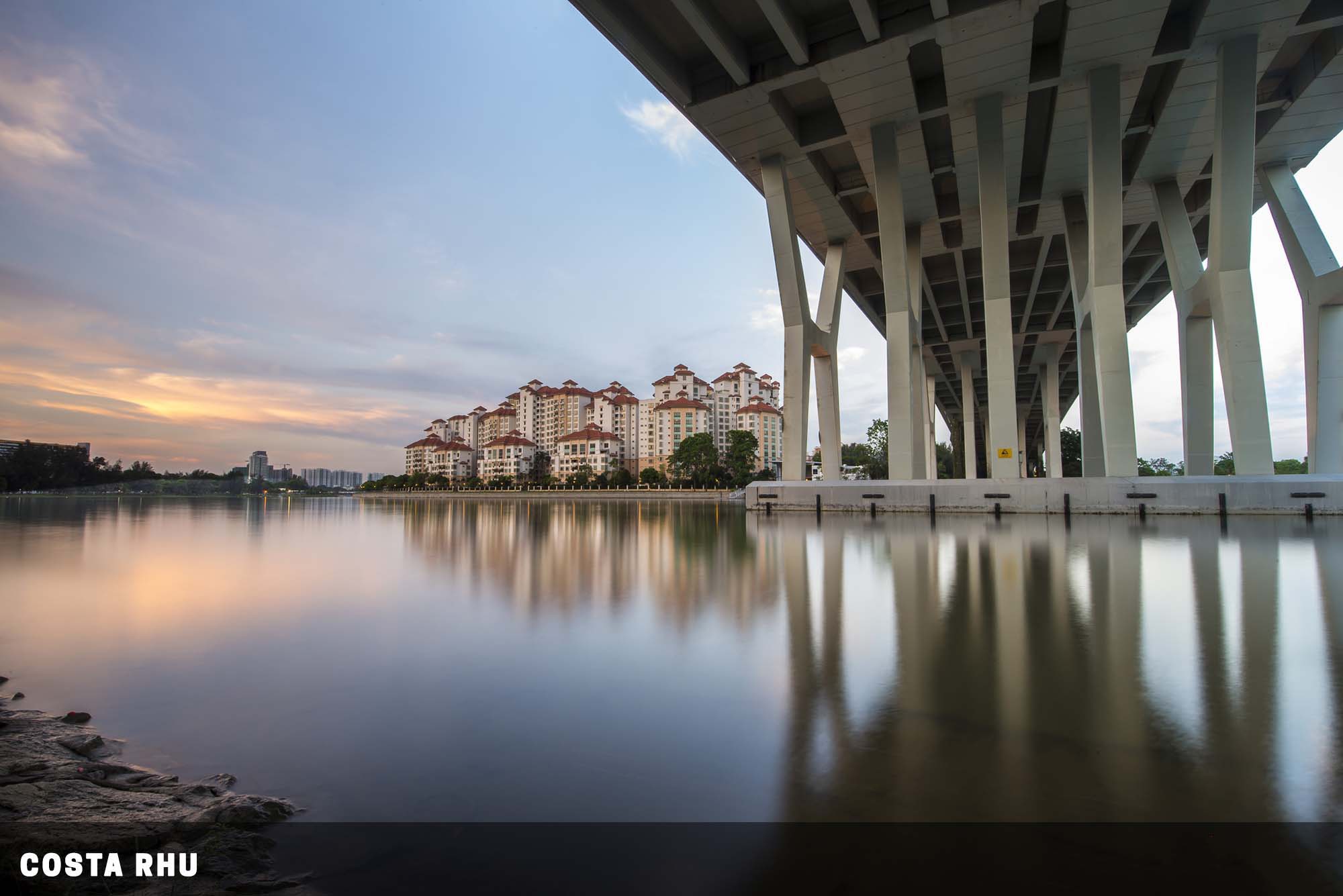
👣 5 minutes from the Nicholl Highway train station. [MAP]
💓 Personally, I love the architecture of Costa Rhu. A good break from the usual HDB (government housing). East facing, this place is good for sunrise photos. Costa Rhu actually sits on the eastern bank, on the side of Stadium MRT.
But to get a good shot of this place, you need to stop at the western bank, the Nicholl Highway station. Also note that the Singapore Sports Hub sits here, which gets crowded and noisy whenever big events are held.
11) Singapore Sports Hub (From Blk 4 Beach Road)
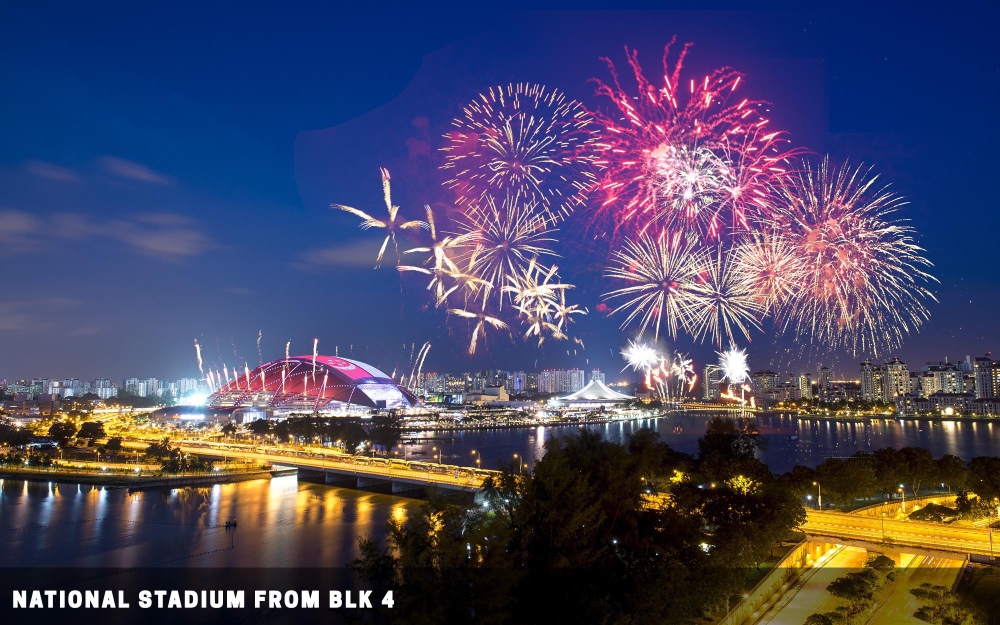
👣 A 15 mins walk from the Lavender MRT station. Go up block 4 of Beach Road, and you will get a bird’s eye view of the river and Singapore Sports Hub. [MAP]
💓 A Pretty exciting place to be whenever there are fireworks display or big concerts.
ORCHARD ROAD
The famous shopping street in Singapore. You can find all sorts of branded and designer stuff here. Keep an eye open, and you will find some interesting stuff to shoot.
12) ION Orchard
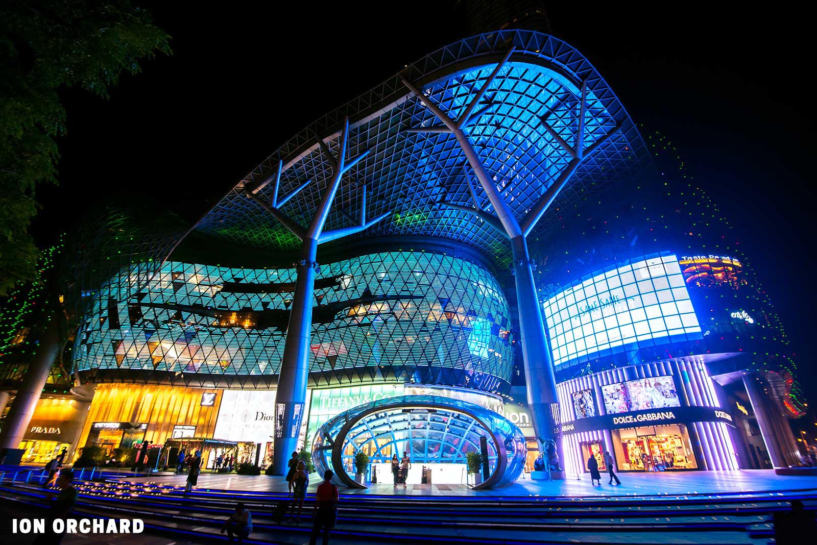
👣 Right beside Orchard MRT Station. [MAP]
💓 Futuristic architecture shopping mall. Shoot at night, when the building lights up like a spaceship.
13) Orchard Road Street Art
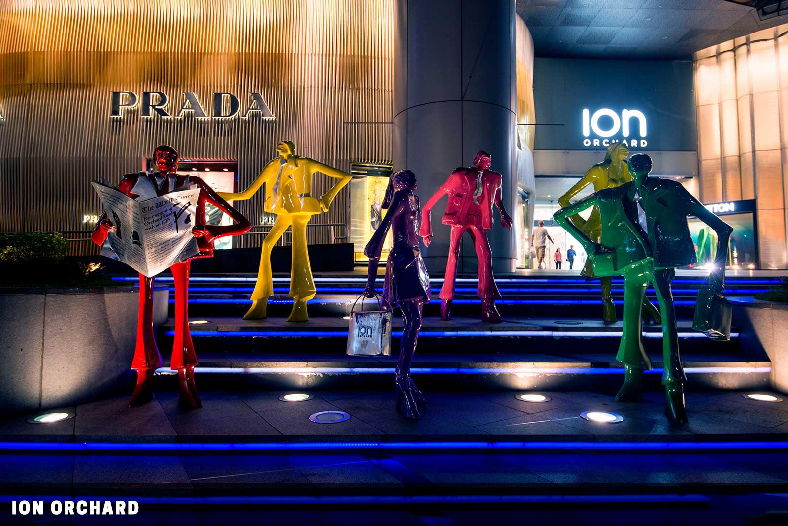
👣 Orchard/Sommerset MRT Station. [MAP]
💓 Plenty of art and performers line up along the streets of Orchard Road, plenty of stuff to see here. Photobomb alert. Expect crowds of people during the weekends.
ARAB STREET
This is called Arab Street because an Arab merchant once owned it. Today, this is a bustling street full of colorful textiles, carpets, and good food. But do be aware that this has somewhat become a “tourist zone”, and the stuff sold here is a little overpriced.
14) Masjid Sultan
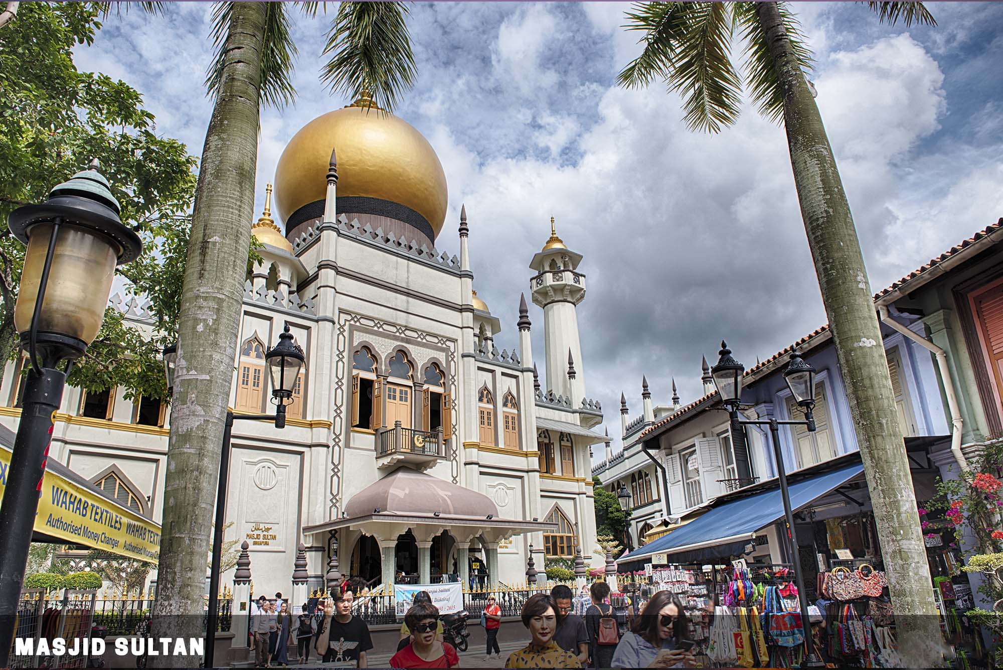
👣 10 min walk from Bugis MRT Station. [MAP]
💓 This mosque is built for a king, and you can expect this to be a very posh one. Remember to take your shoes off before entering Masjid Sultan.
15) Haji Lane & Arab Street
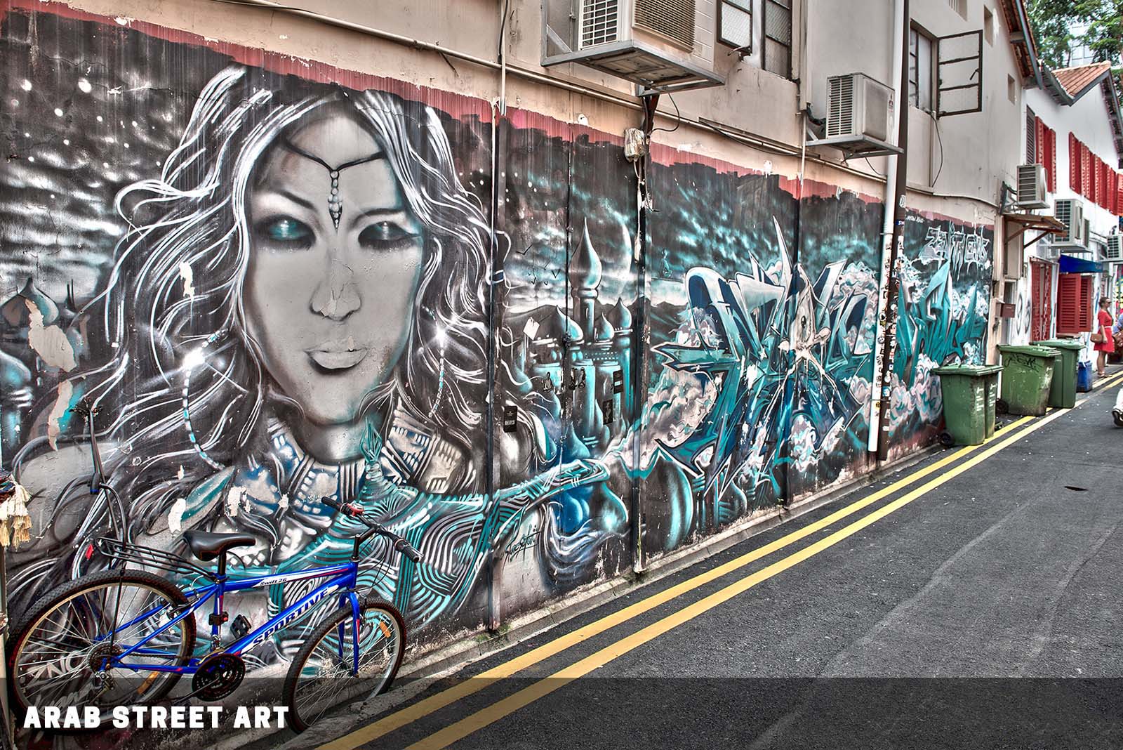
👣 10 min walk from Bugis MRT Station. [MAP]
💓 Hippies have taken over the streets! Plenty of colorful street art to see around here. This area is quite popular among both tourists and locals – You can expect quite a crowd here during the weekends.
CHINATOWN AREA
This place is actually called “Niu Cher Sui” (oxcart water) in Chinese, and not Chinatown. Back in those days, plumbing was non-existent, and people had to buy water from water peddlers on oxcarts. Thus, the name of oxcart water. How it came to have the “Chinatown” name, is probably because of the Chinese majority living there.
16) Buddha Tooth Relic Temple
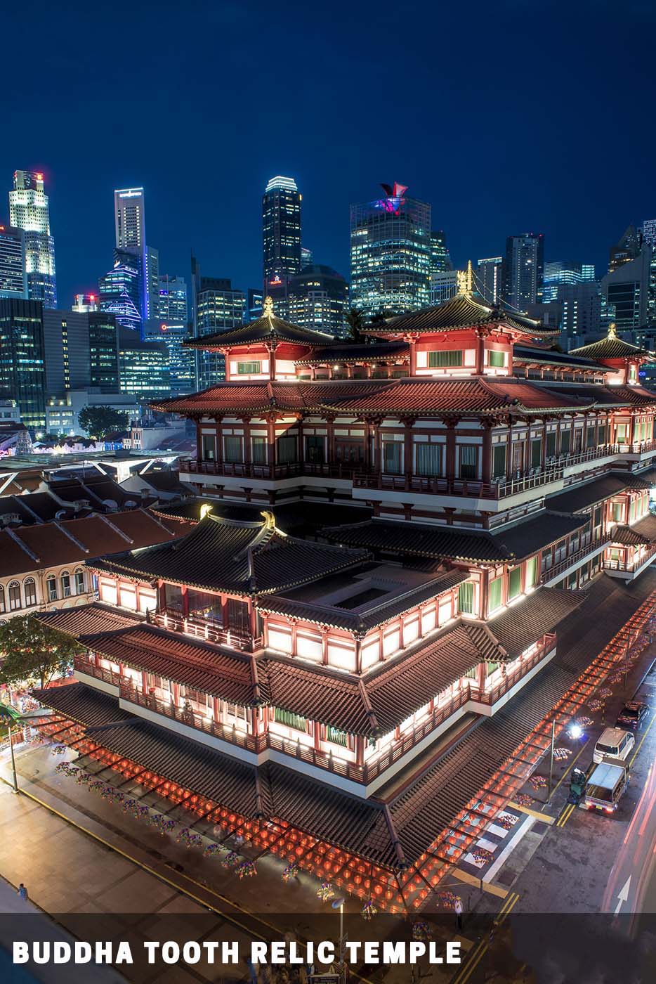
👣 10 minutes walk from Chinatown MRT station. [MAP]
💓 A posh temple and museum that houses several Buddhist relics – Including a fragment of Buddha’s tooth. While the entry is free, do take note that the Buddha Tooth Relic Temple closes at 7 pm. Disrespectful clothing (shirt with f*** you message and that sort) are not allowed. You can go up any nearby public housing to catch a better view of the temple.
17) Chinatown Street
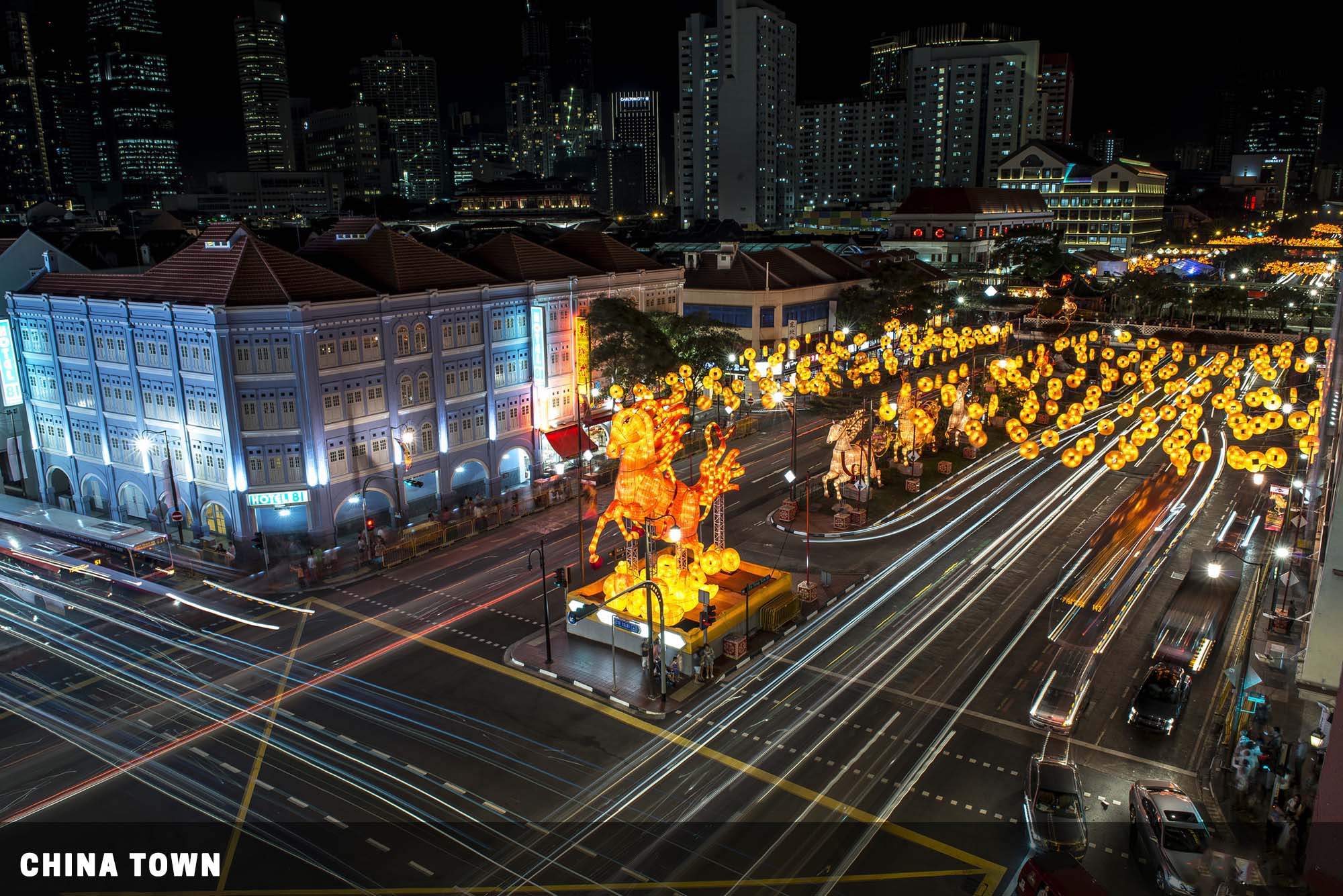
👣 All around Chinatown MRT station. [MAP]
💓 Quite a lot of elderly folks hang out in this area and play chess, plenty of street shots and cityscape. Not all the folks love to have their photos taken without permission. Be discreet and just don’t shove your camera into their faces.
MARINA BAY AREA
This is where the old docks and piers are at, and if you keep your eyes peeled, you might be able to spot a few of those old buildings. Land reclamation has changed the skyline entirely, and in particular, Marina Bay Sands is actually sitting on reclaimed land.
18) Clarke Quay
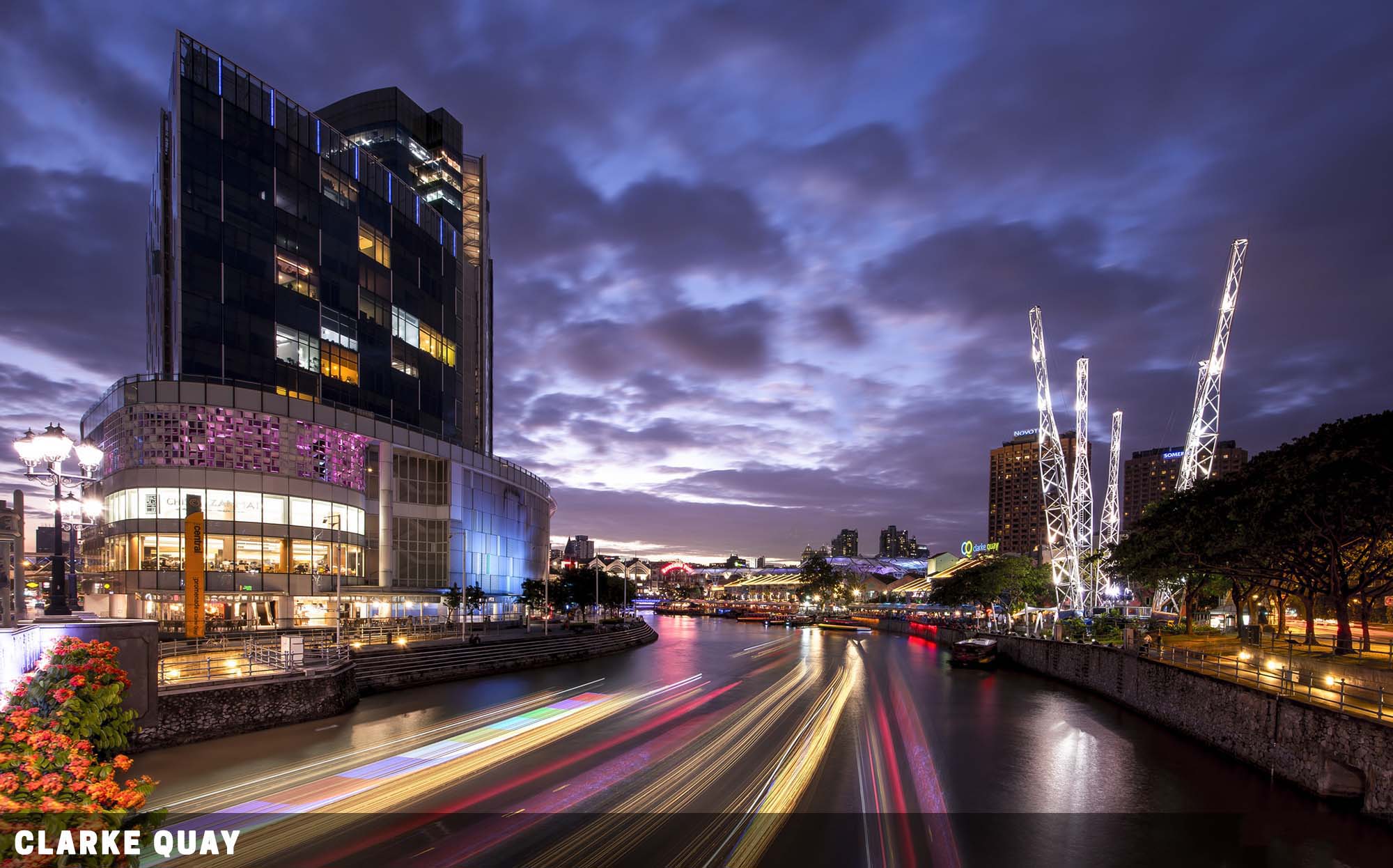
👣 A short walk from the Clarke Quay MRT station. [MAP]
💓 A good place to catch light trails of boats passing by at night, a lot of tourists in the area and the food here is expensive.
19) Suntec City
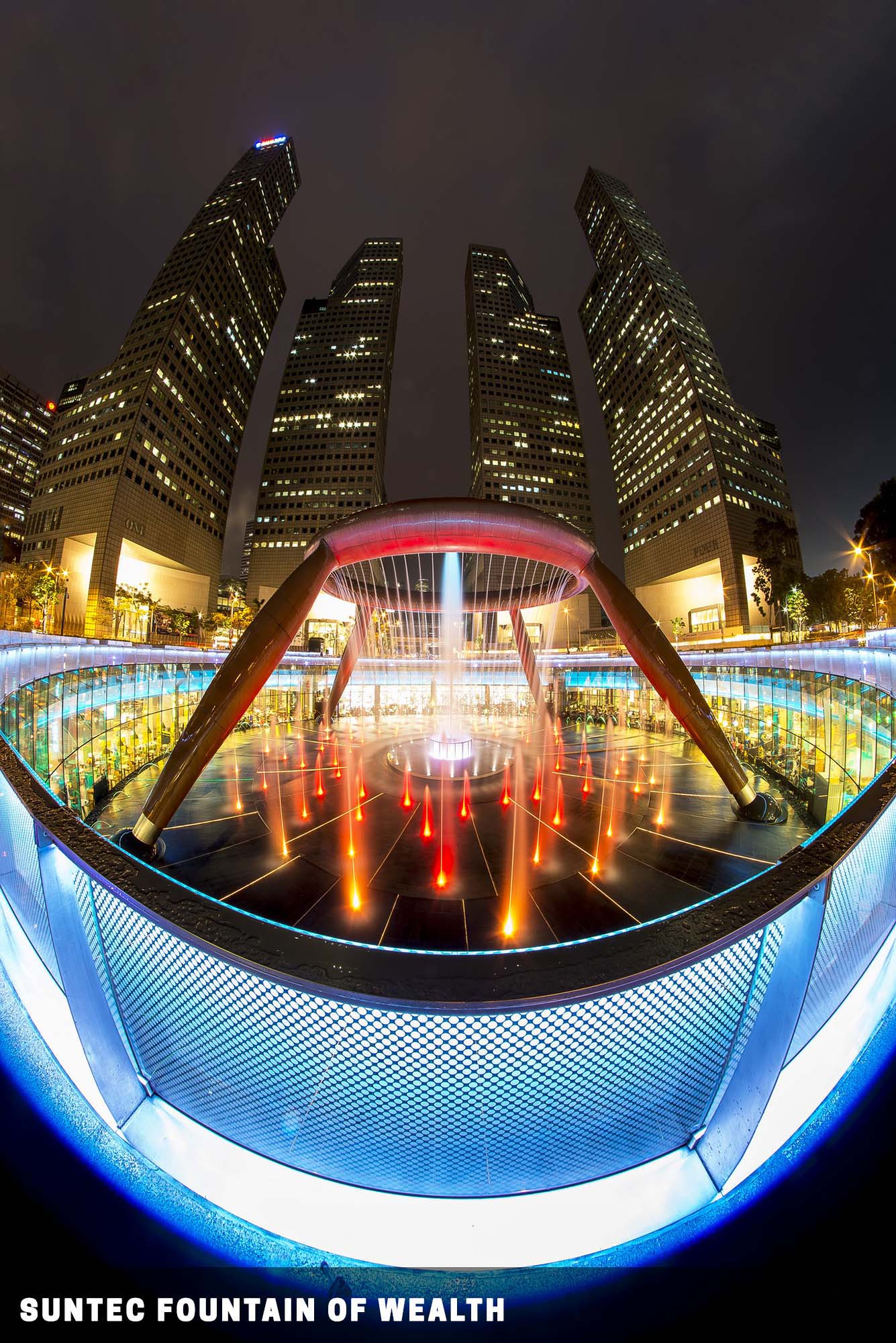
👣 A short walk from the Promenade MRT station. [MAP]
💓 The Fountain of Wealth lights up at night. You will need an extremely wide-angle lens or even a fisheye lens.
20) Marina Bay Sands
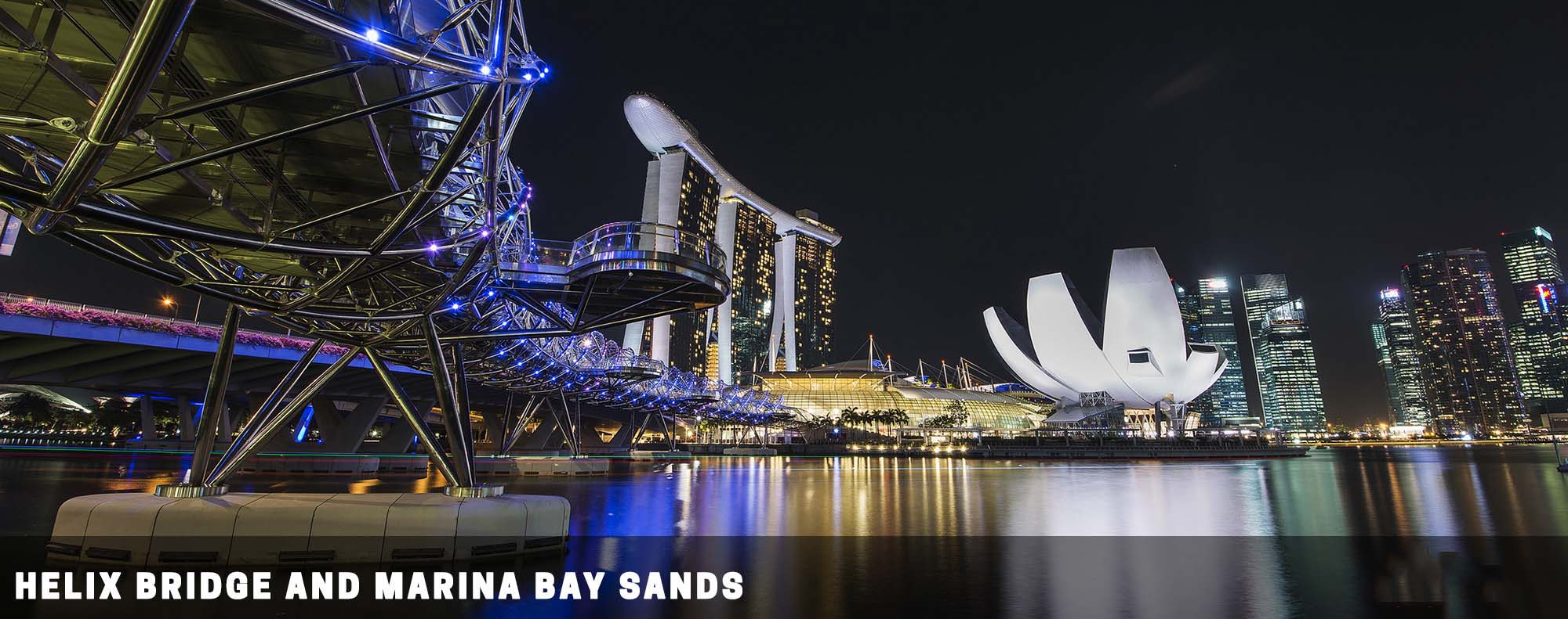
👣 MRT Bayfront station. [MAP]
💓 The famous Helix Bridge, “Flying Ship” and Artscience Museum. It’s the city area. Lots of people during rush hour, do watch out if you carry a lot of photography equipment. Don’t kill people with your tripod by accident. A lot of “touristy” photo spots here, good for night photography and capturing light trails.
21) Esplanade
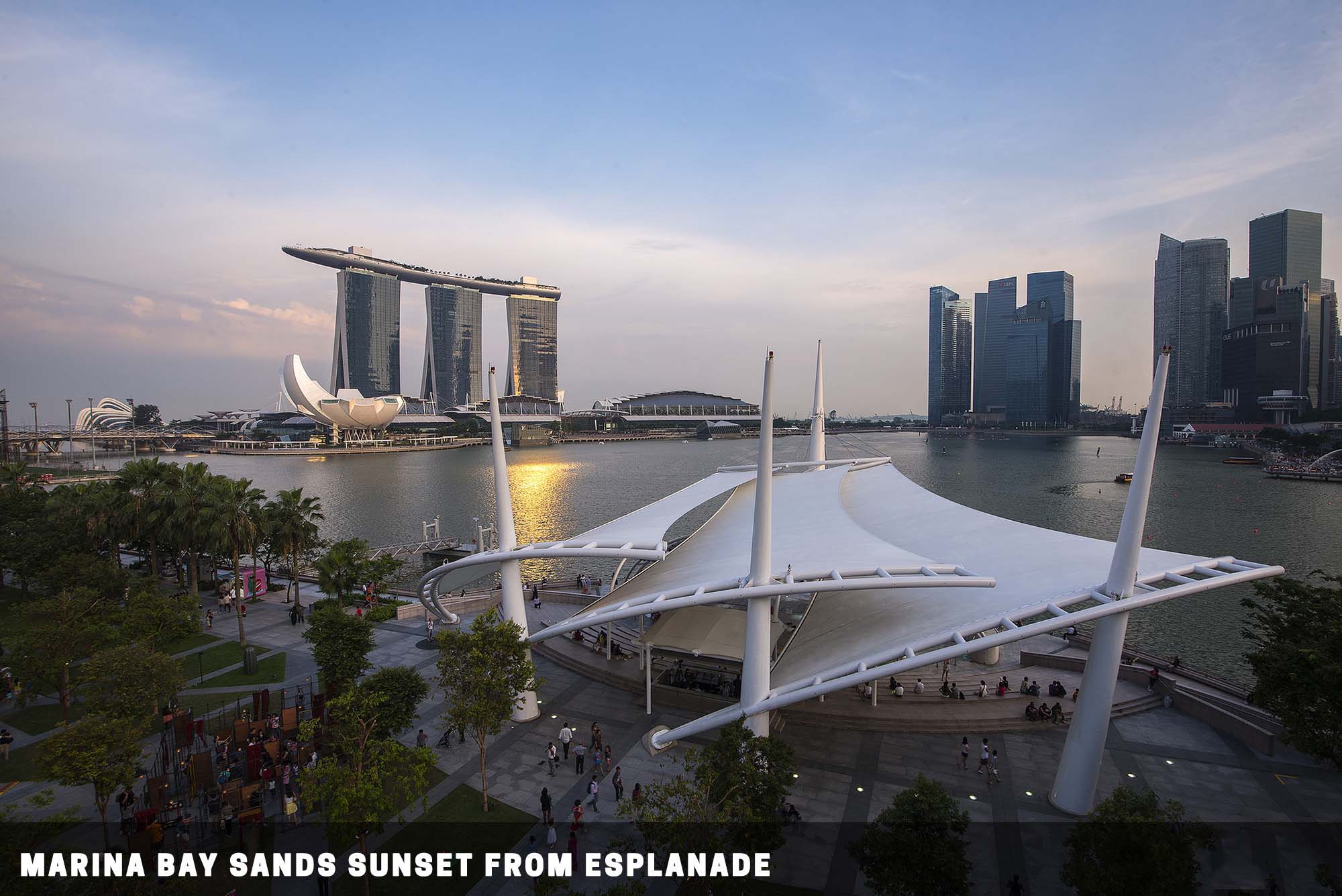
👣 Directly from Esplanade MRT station. [MAP]
💓 An iconic building that locals call “The Durian”. The rooftop is open to the public, and is a very nice vantage point to shoot the Marina Bay Sands wonderful light show at 8 pm. Do not overstay, if I remember correctly, it closes after 10 pm.
22) Merlion Park
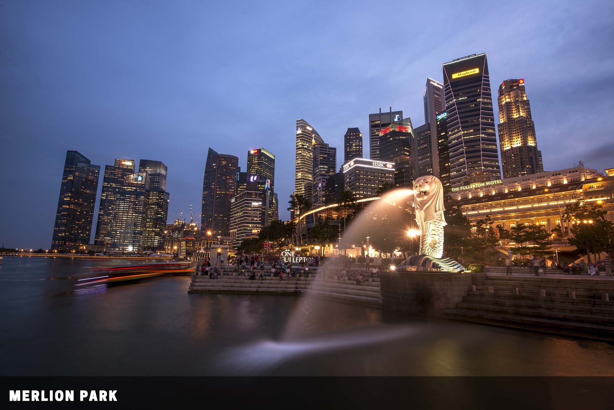
👣 A short walk from the Raffles Place MRT station. [MAP]
💓 The world-famous skyline and Singapore’s mythical creature. This park is always packed with tourists.
23) Marina Coastal Expressway
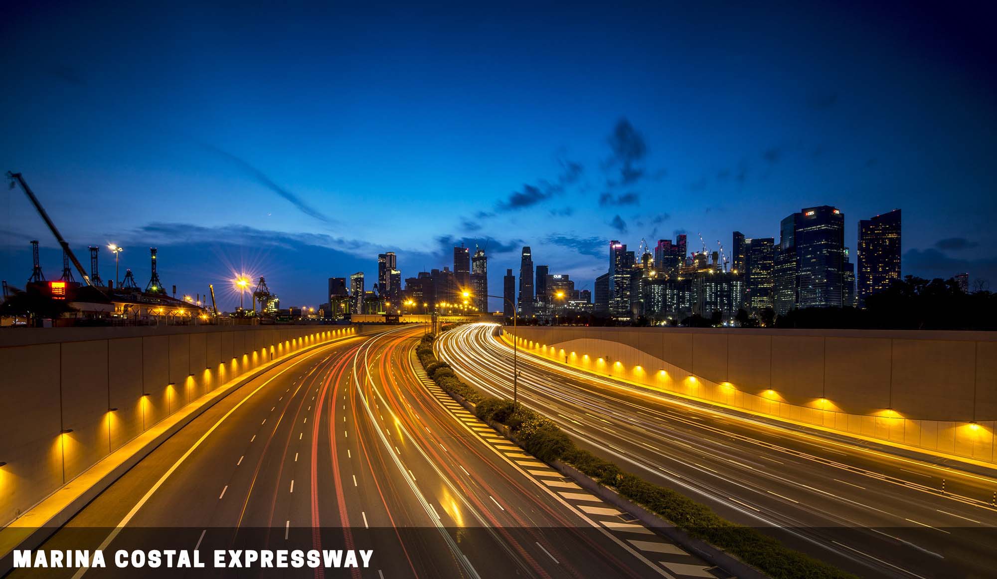
👣 15 minutes walk from Marina South Pier MRT station. [MAP]
💓 Light trails of the passing traffic. This place is actually pretty inaccessible. Wait for the night, possible mosquito and insect pester.
24) Singapore Flyer
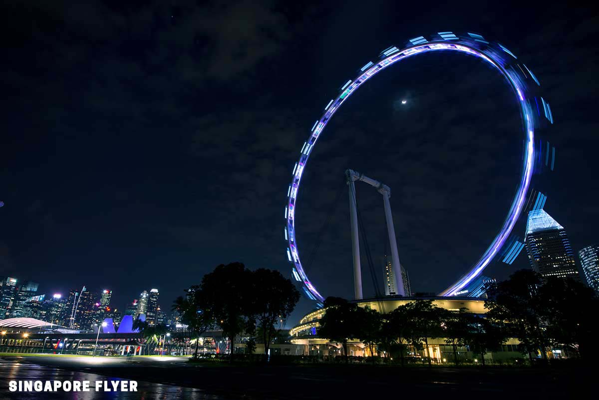
👣 A 10 min walk from Promenade/Bayfront MRT station. [MAP]
💓 You can buy a ticket and hop on the Flyer for some cityscape. Alternatively, you can have a photo of the flyer and Singapore skyline from Gardens by the Bay East. Ticket counter closes at 10 pm if you want to ride the Flyer.
PARKS AND RESERVOIRS
Singapore is an island surrounded by sea and has 5 million in population. This is why water is so scarce, and we have so many reservoirs on this island to provide all the freshwater needs. Good thing is that most of them have “built-in” parks and nature trails that you can enjoy.
RESERVOIRS
25) LOWER PEIRCE RESERVOIR
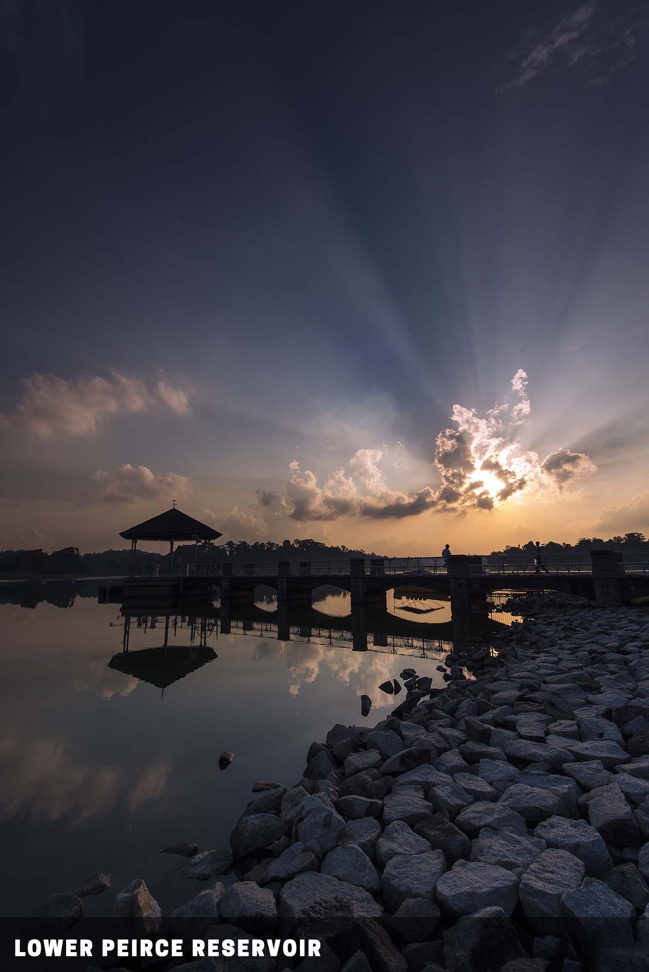
👣 Plenty of buses 132, 163, 165, 166, 167, 855, 980. [MAP]
💓 The second oldest reservoir in Singapore commissioned in 1912. The pavilion against the sunset, rocky coast. Monkeys and wild boars in this area. Avoid bringing food.
26) MACRITCHIE RESERVOIR
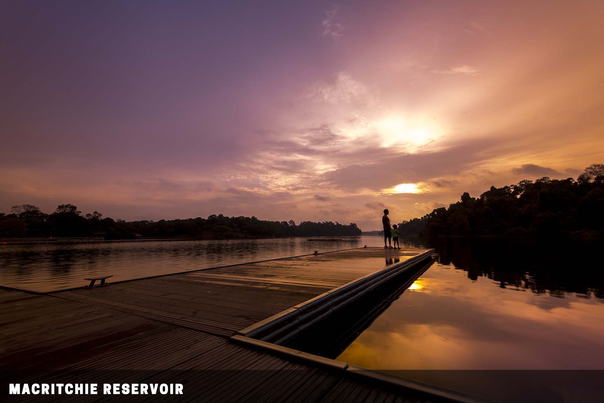
👣 Plenty of buses – 52, 74, 130 ,132, 162, 163, 165, 166, 167, 852, 855 and 980. [MAP]
💓 Singapore’s first reservoir, now a favorite spot for kayakers. The pier at Paddle Lodge during sunset, tree-top walk, and plenty of nature trails. It’s a reservoir and part of a nature reserve. Expect wildlife.
Avoid bringing food, or you will be pestered by monkeys to no end. Do not stray off the walking paths if you decide to enter the nature trails.
27) UPPER SELETAR RESERVOIR

👣 Take bus 138 from AMK Hub, the bus stop for Upper Seletar is rather obscure in the middle of the road. [MAP]
💓 Singapore’s third reservoir, build after World War II to cater to the rising water demand. A scenic reservoir that looks more like a lake. A few vantage points such as the jetty, rocket tower, and “marriage tree”. Possible mozzie attack, monkey pester. Avoid bringing food.
28) MARINA BARRAGE
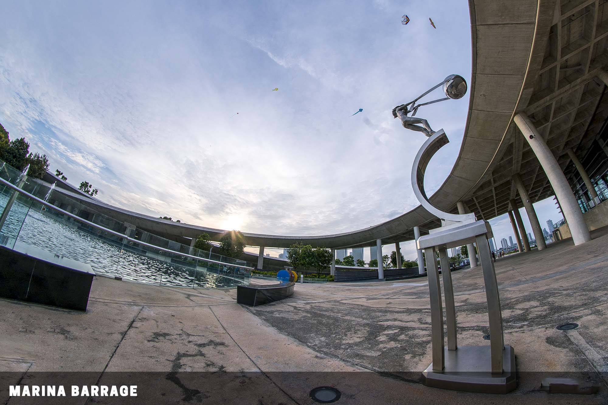
👣 At the edge of Gardens By The Bay. Take bus 400 from the bus stop beside Marina Bay Sands (in front of Marina Bay Link Mall). [MAP]
💓Opened in 2008, the barrage keeps out seawater and is actually Singapore’s 15th reservoir. People usually kite here during the weekends. You might catch some good “sky fish” here. A rather isolated place at the edge of the city.
GARDENS BY THE BAY
29) GARDENS BY THE BAY WEST
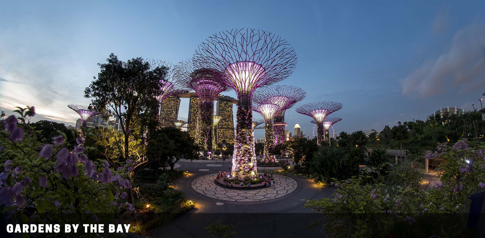
👣 10 mins walk from MRT Bayfront station. [MAP]
💓A sprawling park that is completed in 2012. Costs billions to build and made its way onto the world map. The famous supertrees at night, the flower dome, and cloud forest. Tourist-heavy zone.
Expect a lot of people during weekends. Entering the park itself is free, but you will need to pay an entrance fee for the flower dome and cloud forest.
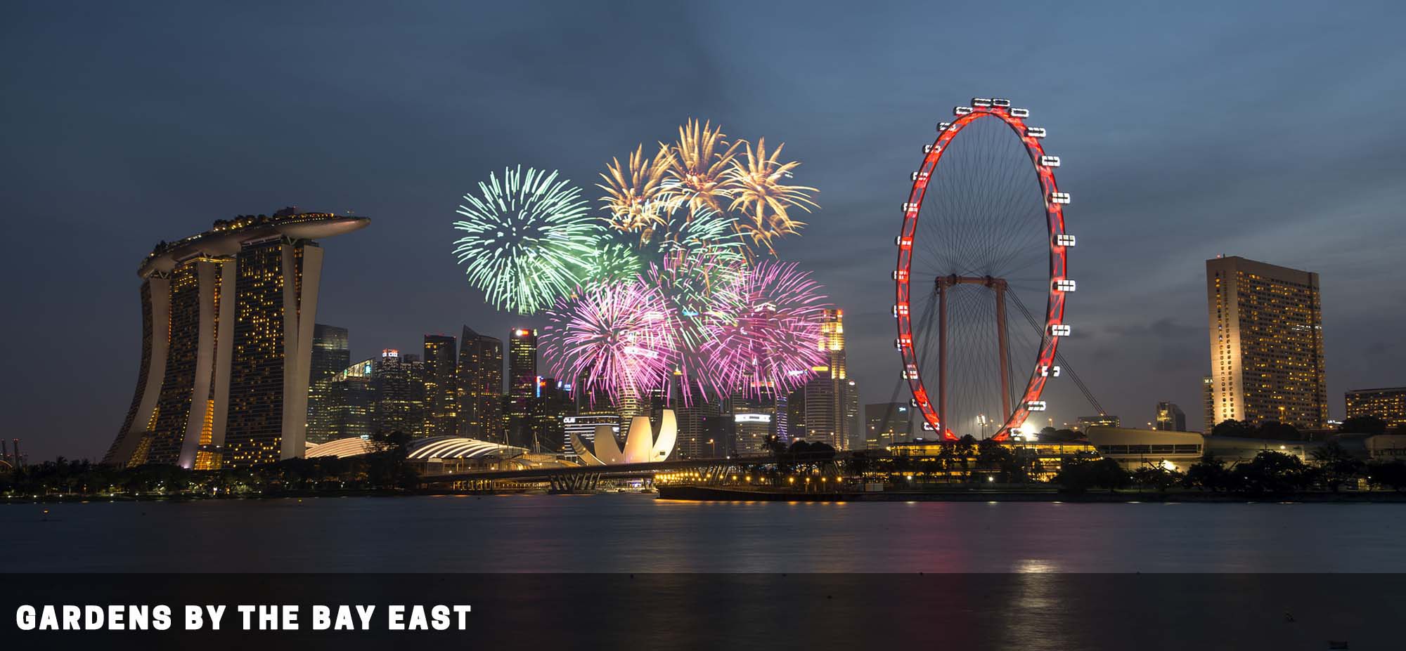
30) GARDENS BY THE BAY EAST
👣 Cross the bridge from Marina Barrage, or 15 minutes walk from Stadium MRT. [MAP]
💓 This is still a part of Gardens by the Bay, but lesser-known because it is not as accessible. Catch a beautiful skyline of Singapore city from this spot, especially during sunset.
Not very accessible and a lot of walking… Cycle if you can. Come during the sunset hours (5 pm +) to avoid getting burnt to crisp from the afternoon sun.
PARKS
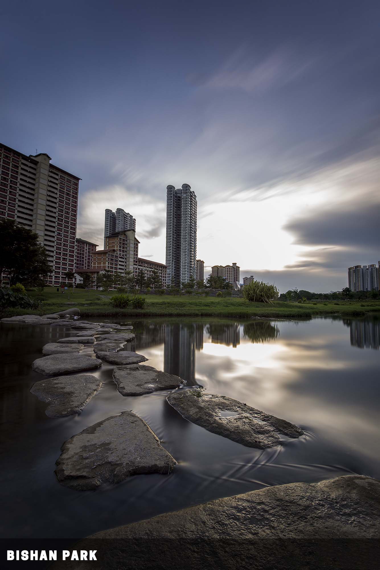
31) BISHAN PARK
👣 Various buses from Ang Mo Kio bus interchange – 133, 136, and 262. [MAP]
💓 If I were to say that this place used to be a cemetery, many will shake their heads in disbelieve. Bishan park is now a huge man-made river plain. Sunset and plenty of opportunities by the river.
Mozzie attack, the river is safe to walk into during “low tide”. Just know that you will get wet… and do run for shelter during lightning storms. You do not want to stay outside in an open area.
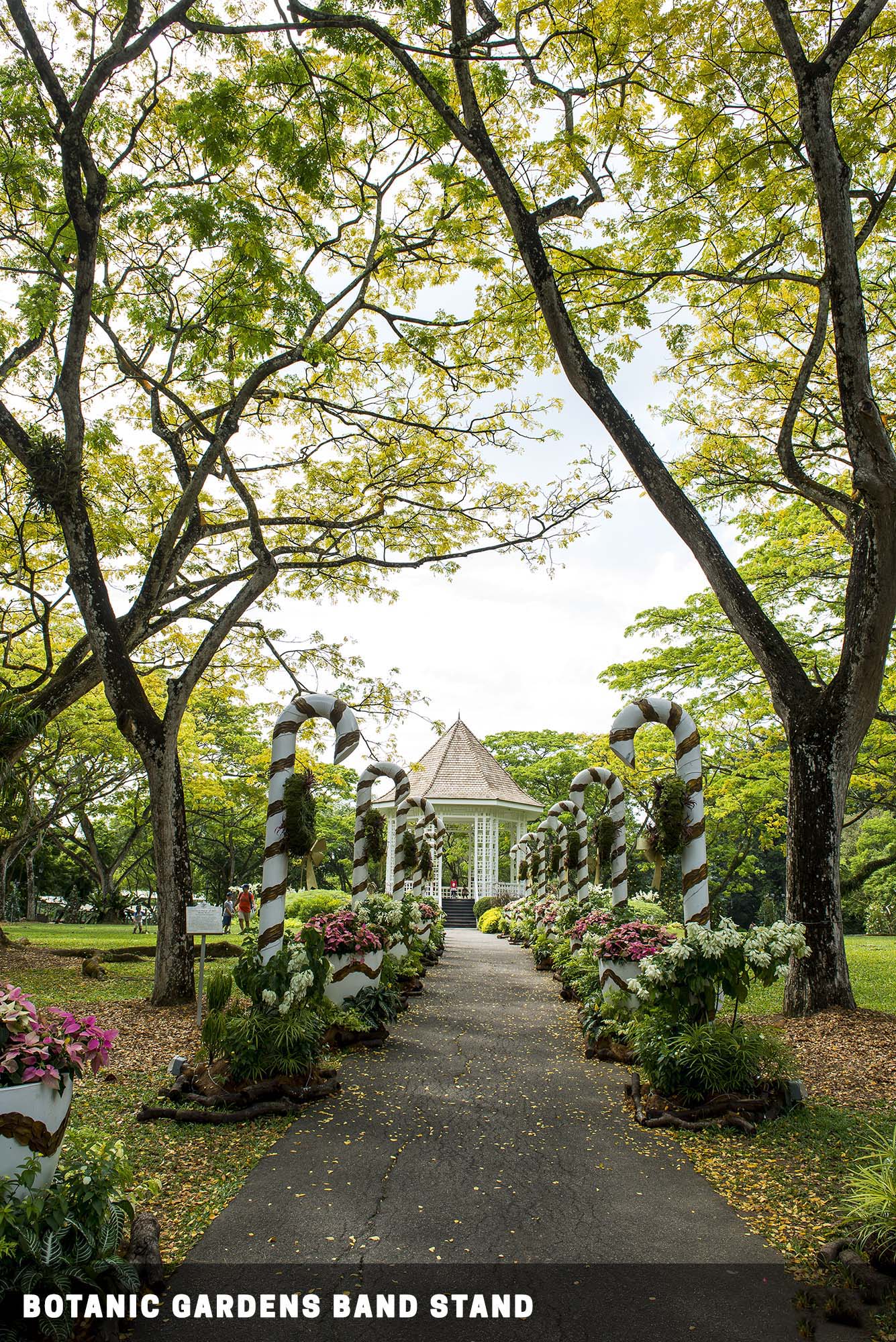
32) SINGAPORE BOTANIC GARDENS
👣 Right beside Botanic Gardens MRT Station. [MAP]
💓 Founded in 1859, way before Singapore’s independence as “an experimental garden”. It has gone a long way and is now a UNESCO heritage site. Plenty of nature and our national flower – the orchid garden. The bandstand, heritage trail, symphony lake, the orchid garden.
An oasis in the middle of busy Singapore. The Botanic Gardens close at 12 am, and the Orchid garden at 7 pm… don’t get stuck inside.
33) PUNGGOL JETTY PARK
👣 Take bus 84 from Punggol Interchange. [MAP]
💓 This is yet another park that has seen history. It was once an execution site during the Japanese occupation in WW2. Today, it is a nice and peaceful beach to chill out. Come here during sunset and low tide to catch the jetty and rocky beach. Watch out for incoming tides though, they can rise pretty fast.
34) JAPANESE CEMETERY PARK
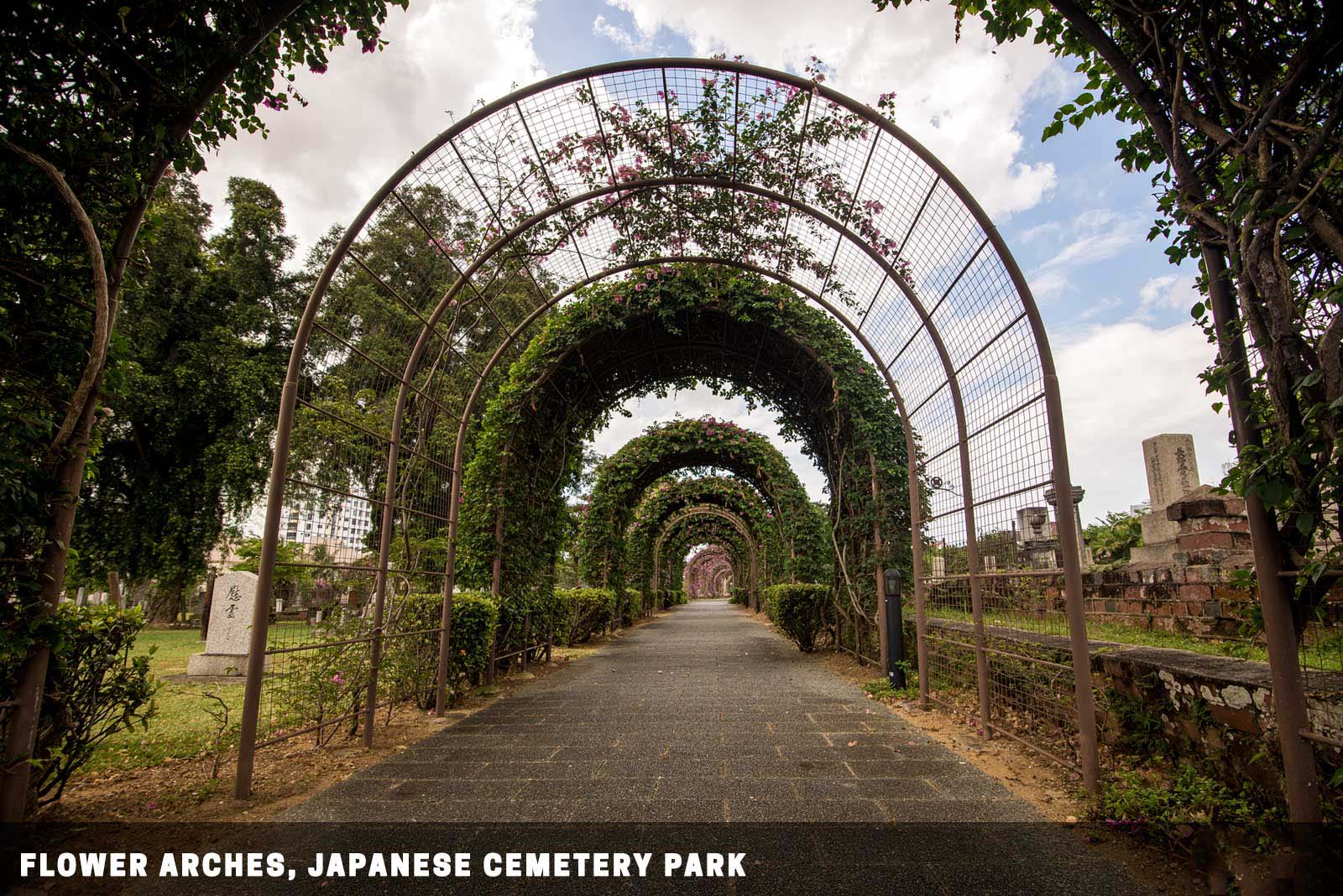
👣 Take bus 76 or 70M from Yio Chu Kang Interchange, stop at the Foursquare Gospel Church bus stop. Take a 5 minutes walk thereafter. [MAP]
💓 A small piece of history in Singapore. Nice flower arches, and very Japanese architectures in Singapore. This cemetery lies hidden in the middle of private properties. Many people might think there is nothing to shoot in a cemetery, maybe except for graves. Not this one.
This is a cemetery park… You can enter, enjoy a slow walk, and soak in some of that history. This is still a cemetery though, refrain from doing stupid things that will disrespect the resting elders.
EVEN MORE PLACES
Holy moly. Singapore is actually so big that I don’t have all the photos. These are the places that I do not have decent photos of, shall revisit them someday and add them to the list.
PARKS & RESERVOIRS
35) LOWER SELETAR RESERVOIR
👣 Take a 10 min walk from Khatib MRT Station [MAP]
💓 East facing, good for sunrise shots. Beware of mozzie attack!
36) PANDAN RESERVOIR
👣 Take bus 176 or 51 from Jurong East Interchange. [MAP]
💓 Good for sunrise and sunset, depending on which side you are on. Possible mozzie attack.
37) BEDOK RESERVOIR
👣 Take bus 69, 22, 28, 67, 65 or 18 from Tampines Interchange. [MAP]
💓 Good for sunrise and sunset, depending on which side you are on. Possible mozzie attack.
38) PUNGGOL WATERWAY PARK
👣 Take bus 84 from Punggol interchange, stop at the waterway park. [MAP]
💓 This is quite a popular location among joggers. Expect some walking.
39) PUNGGOL RIVERSIDE WALK / LORONG HALUS
👣 Take the LRT from Punggol interchange, stop at Riviera station. Take a 10 mins walk. [MAP]
💓 A lot of walking again. Do watch the weather forecast, this area is open and prone to lightning strikes.
40) WOODLANDS WATERFRONT PARK
👣 Take bus 856 from Marsiling MRT station. [MAP]
💓 The jetty, a panorama shot of Johor Bahru during the blue hour. The skyline of Johor Bahru is sadly restricted to the jetty only. The rest of the area is all fenced up.
41) BUKIT BATOK TOWN PARK (LITTLE GUILIN)
👣 Take a 10 min walk from Bukit Gombak MRT station. [MAP]
💓 Sunrise at Little Guilin, reflections on the water. Pretty much boring once you get that “one-shot”.
42) TELOK BLANGAH HILL PARK
👣 Take bus 176, 272 or 273 from Bukit Merah Interchange. [MAP]
💓 Terrace garden and Henderson Waves lighted up during the blue hour. A lot of walking if you do not have personal transport.
43) CHINESE GARDEN / JAPANESE GARDEN
👣 Take a 5 mins walk from Chinese Garden MRT station. [MAP]
💓 The main gates, bridges, twin pagoda. A lot of walking if you do not have personal transport
44) SUNGEI BULOH WETLAND RESERVES
👣 By cab, or 925C from Woodlands Interchange (Sundays and PH only). [MAP]
💓 Wildlife, birds. Inaccessible place… you will need some wheels to get there, but a good place to catch some wildlife.
45) PULAU UBIN
👣 Take a ferry off Changi Point Ferry Terminal. [MAP]
💓 A lot of stuff. Landscape and be prepared to go back to the 70s. Do take note of the timing for the last ferry. Although staying there overnight for sunrise is also another option.
46) HORTPARK
👣 Take bus 100, 120, 166, 51, or 61 from Labrador Park MRT. [MAP]
💓 An “Instagram worthy” park that has a European flair.
CITY AREA
47) REFLECTIONS @ KEPPEL BAY
👣 A long walk from HarbourFront MRT station. Enter from Keppel Bay Drive, follow along the pedestrian path, turn left before Keppel Bay Vista, and walk again. [MAP]
💓 Reflections against the sunset. A lot of walking.
48) SENTOSA
👣 10 minutes walk from Harbourfront MRT station, take a bus or the monorail train. [MAP]
💓 Various photogenic spots, including the Merlion Statue, Beaches and Resort World Sentosa. Tourist zone. Expensive transport, food, and drinks.
49) EMERALD HILL
👣 5 minutes walk from Orchard MRT station. [MAP]
💓 An alley behind the busy Orchard Road. It still has colonial-style houses that are marked as heritage buildings.
EVENTS & EXTRAS
There are plenty of interesting events in Singapore – This section is dedicated to the places that will only light at certain times or occasions. P.S. As there are way too many events and I can’t squeeze all of them into this post, these are the few that I have selectively picked.
FESTIVALS
The following places will be “dressed up” over various festival seasons.
- Chinatown [MAP] – Chinese New Year (between Jan and Feb)
- Little India [MAP] – Deepavali (Diwali, date varies)
- Orchard Road [MAP] – Chinese New Year, Deepavali, Christmas, etc…
LIGHT SHOWS
Plenty of light shows all over the island, all year round.
- Marina Bay Sands – Daily at 8 PM and 9 PM, the Spectra Light Show. [Link]
- Gardens By The Bay – Daily at 7.45 PM and 8.45 PM at the Supertree Grove. Garden Rhapsody Light Show daily. [Link]
- Changi Jewel – Rain Vortex daily from 7.30 pm to 11.30 pm, at hourly intervals. [Link]
- Sentosa – Daily at 8 PM, light and mechanical show, plus small fireworks every Saturday night at the crane dance. [Link]
- Marina Bay – Depends, iLight Marina Bay display works of illuminated art. [Link]
- City Area – Depends. Singapore Night Festival has plenty of light, performance, and art stuff. [Link]
FIREWORKS
Singapore Fireworks 2020- NDP, New Year, Best Places and Timing
PERSONAL PICKS – BEST PLACES
We have come to the end of this long list, and just which are the most photogenic places in Singapore? Well, I guess everyone has their own preferences, but here are my personal picks :
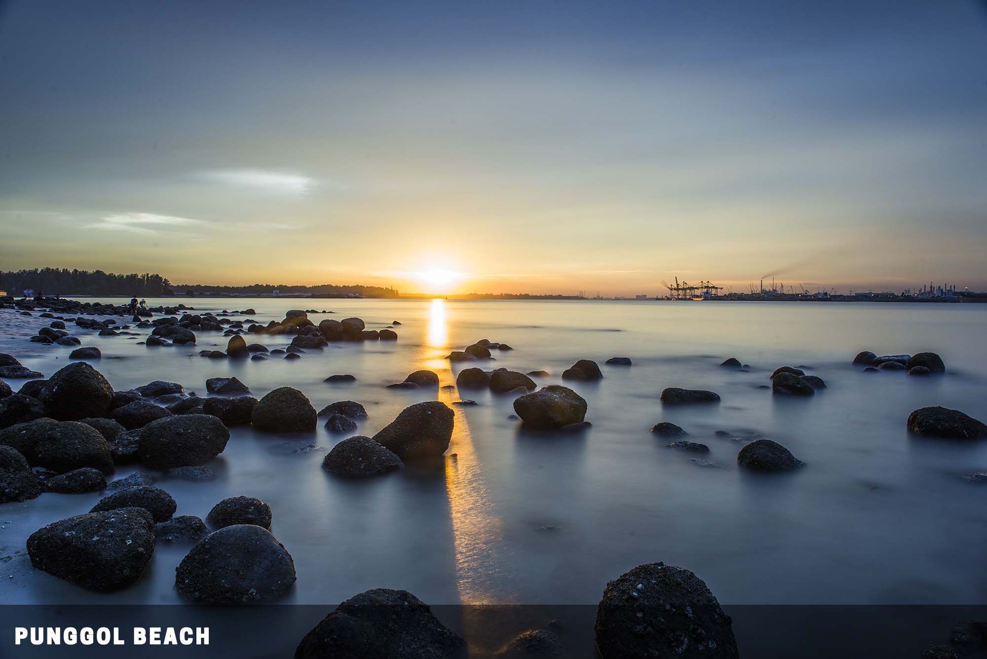
- Punggol Rocky Beach – The rocky landscape on this beach is a good escape from the usual concrete jungle.
- The rooftop of Esplanade – Normally, this is quite a boring place. But this becomes one of the better vantage points when the light show at Marina Bay Sands fires up at 8 pm.
- Gardens By The Bay East – Quite a bit of walking to be done here, but during sunset, you will get a beautiful skyline of Singapore City.
- Clarke Quay – Plenty of stuff to explore here at night. Light trails, street, and nightlife.
- MacRitchie Reservoir – One of my favorite haunts. Sunset at the pier offers the best views, and you can also catch Kayakers here.
With this, I shall now sign off. If you have any questions, please feel free to comment below. Happy shooting!